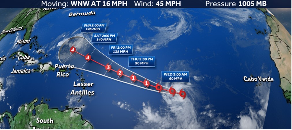
Tropical Storm Lee is projected to rapidly grow into an “extremely dangerous” Atlantic Ocean hurricane by this weekend, the National Hurricane Center said Wednesday morning. The season is approaching its annual early September peak.

Tropical Storm Lee is being tracked (Source: WDSU)
Hazardous Waves are Expected from Tropical Storm Lee
Forecasters expect Tropical Storm Lee to become a hurricane Wednesday and a major Category 3 storm or stronger by late this week, affecting the Leeward Islands of the Caribbean during the weekend. “Lee is not far from hurricane strength, and it likely will achieve that status later today,” the National Hurricane Center said at 5 a.m. “While it is too early to determine the location and magnitude of these possible impacts, interests in this area should monitor Lee’s progress and forecast updates.” The hurricane center reports 65 mph sustained winds from the tropical storm 1,300 miles east-southeast of the northern Leeward Islands. The Virgin Islands, Saint Martin, and Antigua & Barbuda are included.
Swells from tropical storm Lee are forecast to reach the Lesser Antilles on Friday. These surges may generate deadly surf and rip currents. The storm center predicts 150 mph winds for Lee on Sunday evening. Changes in its route as it approaches the islands could affect them and beyond. The eastern Caribbean, including the Leeward Islands, Puerto Rico, Hispaniola, and the Bahamas, should watch the forecast.
Even if the cyclone lingers out at sea, hazardous waves and rip currents could again menace the East Coast. Over Labor Day weekend, a rip current in New Jersey killed one person. According to the National Hurricane Center, Lee formed Tuesday morning in the central tropical Atlantic and moved across abnormally warm waters. It is expected to grow fast. Rapid intensification occurs when storm winds strengthen quickly. Warm ocean waters help scientists describe it as a 35-mph wind speed increase in 24 hours or less.
READ ALSO: National Hurricane Center Forecasts Developing Tropical Storms Giving Warning to the Citizens
Tropical Storm Lee is Likely to Impact Like a Hurricane
As tropical storm Lee moves west-northwest this week, strengthening conditions will improve: Moisture, low wind shear, and abnormally warm water cover most of the possible cyclone’s path. “The NHC intensity forecast is extremely bullish for a first forecast, but remarkably lies below the intensity consensus,” the hurricane center storm discussion noted. All indicators are that the depression will become a powerful hurricane by the anticipated end.”
That would make Lee the fourth this season after Don, Franklin, and Idalia. The hurricane is predicted to become the season’s third Category 3 or stronger hurricane by the weekend. The Atlantic hurricane season peaks on Sunday, September 10, when the basin is busiest. Tropical activity around this period is common, but it can be dangerous.
According to Colorado State University research scientist Philip Klotzbach, the 2023 Atlantic season is above average for named storms, hurricanes, and major hurricanes.
READ ALSO: Warnings are Announced as Tropical Storm Idalia’s Path May Take to Florida


