After a brutal September and early October, Florida is ready for a reprieve from hurricanes.
According to experts, the next two weeks are a toss-up.
In their two-week forecast report, Colorado State University meteorologists said they see a 50% chance of above-normal activity in the Atlantic basin, a 40% chance of near-normal activity and a 10% chance of below-normal activity.
There’s a bright spot, though. “Normal” for the second half of October is typically less active than late August through early October, the traditional peak of hurricane season. The sun’s angle is lower, prompting subtle water cooling, meaning less fuel for storms.
There are still patches of hot water in the Atlantic Basin, though, and hurricane season runs through the end of November.
CSU’s previous two-week forecast unfortunately proved to be accurate, when it predicted with “virtual certainty” that Oct. 1 through Oct. 14 of the hurricane season would have above-normal activity. The past month has drawn lots of storm activity: Hurricane Helene made landfall on Sept. 26 in the Big Bend area of the Florida Gulf Coast. And last week, Hurricane Milton ravaged Florida and the Southeast.
The first two weeks of October — with Hurricanes Milton, Kirk and Leslie — generated the third-most Accumulated Cyclone Energy (ACE) of any two-week period, trailing only 1893 and 2016.
To predict the next two weeks of storms, meteorologists use Accumulated Cyclone Energy (ACE), the collective strength and duration of Atlantic tropical storms and hurricanes occurring during a given time period.
The university compared the anticipated ACE for the last two weeks of October with normal ACE from the same monthly period from 1966-2023.

To anticipate ACE, they looked at current storms, the National Hurricane Center’s Tropical Weather Outlook and various global models.
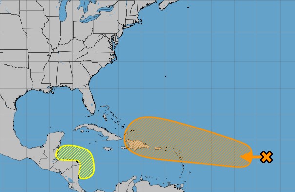
There’s currently a system in the Atlantic that has a 60% chance of becoming a tropical cyclone as it heads toward the Caribbean. Ironically, If the storm were to turn north, away from land, it might actually last longer and produce more ACE.
There’s also a system in the western Caribbean, near Belize, with a 30% chance of developing. CSU said this system would likely only generate small levels of ACE.
Colorado State University also looks at the Madden-Julian oscillation (MJO), which is a weather pattern that travels around the planet, enhancing stormy weather or calm weather. In the second half of October, the MJO will be over the western Pacific, which generally weakens Atlantic hurricane activity.
But CSU said wind shear in the Caribbean looks like it will be below normal for the next two weeks, which could enhance tropical cyclone formation in the Caribbean.
Originally Published:


