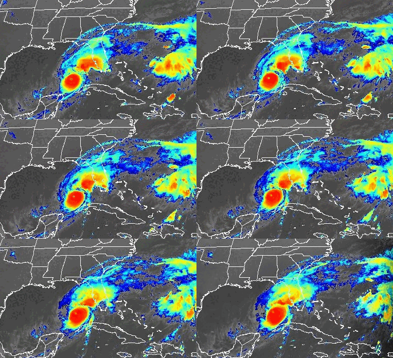
Millions of Floridians in the near-certain path of Category 4 Hurricane Milton have just hours remaining to prepare for — or evacuate from — the monstrous storm, which is forecast to strike a devastating blow to the central Gulf coast, then carve a path of destruction to the opposite side of the state.
Milton is expected to come ashore within 40 miles north or south of Sarasota with the potential to be “one of the most destructive hurricanes on record” for Florida. The potential landfall zone includes Tampa Bay, home to more than 3.3 million people, which has not endured a direct hit from a hurricane in more than 100 years.
The weather on the west coast has already started to deteriorate ahead of the monstrous storm, which was packing wind speeds of 155 mph as of 8 a.m. Wednesday, when the storm was just 250 miles from Tampa. The wind speeds had slowed slightly after being at Category 5 strength — 160 mph — earlier in the morning.
The National Hurricane Center predicted Milton would likely continue to weaken in the hours before landfall, but it will be too late to spare the state from the storm’s catastrophic impacts. Forecasts call for Milton to be at least a Category 3 hurricane at landfall, and remain a hurricane during its entire path across the state.

Gov. Ron DeSantis said at a media briefing late Tuesday that the storm’s track could put several million Floridians at risk, compared to Hurricane Helene, which made landfall in the sparsely populated Big Bend region. “You start talking about the greater Tampa Bay area, that’s millions of people, and then if the storm rides I-4, out to the Atlantic, that’s many millions more.”
Even as Milton weakens, its wind field will grow considerably, hurricane center forecasters said, bringing a large area of tropical-storm force and hurricane-force winds, especially on the storm’s northwest side.
Making matters worse, tides on the Gulf coast will be incoming around the time of Milton’s landfall, exacerbating the storm surge, which could reach 12-15 feet in some spots. High tide peaks between 4 a.m. and 6 a.m. Thursday in the area around Sarasota and Tampa Bay.
“This is an unusual and extremely concerning forecast track for a hurricane approaching the west-central Florida coast and the Tampa Bay area,” warned AccuWeather Chief Meteorologist Jonathan Porter, “For many, Milton may be a once-in-a-lifetime hurricane in terms of severity.”
Thousands of fleeing cars clogged Florida’s highways ahead of the storm, but time for evacuations was running out Wednesday. Tampa Mayor Jane Castor noted that up to 15 feet of storm surge forecast for her city would be deep enough to swallow an entire house.
“So if you’re in it, basically that’s the coffin that you’re in,” Castor said.
The Sun Sentinel has made its coverage of Hurricane Milton free to all readers as a public service. Please consider supporting important breaking news such as this by subscribing to SunSentinel.com at a special rate.
Authorities have issued mandatory evacuation orders across 11 Florida counties with a combined population of about 5.9 million people, according to U.S. Census Bureau estimates.
Officials have warned that anyone staying behind must fend for themselves, as first responders are not expected to risk their lives attempting rescues at the height of the storm.
After weakening early Tuesday during an eyewall replacement in the Gulf of Mexico — something which typically happens in large hurricanes — Milton’s winds increased to 165 mph later in the day and were at 155 mph as of early Wednesday. On Monday, Milton had intensified at an astonishing rate with barometric pressure plunging below 900 millibars, making it one of the top five most intense Atlantic hurricanes on record.
A hurricane hunter aircraft reported early Tuesday evening the pressure in the eye of Milton was plunging yet again, indicating another explosive intensification. Colorado State University meteorologist Philip Klotzbach said in a post on X that the only other hurricane on record in the Atlantic with a lower pressure this late in the year was Hurricane Wilma in 2005.
As of 8 a.m. Wednesday, Hurricane Milton was located about 250 miles southwest of Tampa, moving northeast at 16 mph. Hurricane-force winds extended outward up to 30 miles from the center, and tropical-storm-force winds extended outward up to 125 miles from the center, the National Hurricane Center said in its latest advisory.
The hurricane center issued a multitude of watches and warnings ahead of the storm. South Florida is under a tropical storm warning with high winds from 58-73 mph and heavy rain possible, despite being far from Milton’s forecast path.
Officials warn South Florida to be ready for ‘ugly monster’ known as Hurricane Milton
- A hurricane warning has been issued for the west coast of Florida from Bonita Beach north to the mouth of the Suwannee River, including Tampa Bay.
- A tropical storm warning has been issued for the west coast of Florida south of Bonita Beach to Flamingo, including Lake Okeechobee.
- There is a tropical storm warning for the Florida Keys, including the Dry Tortugas, extending north through Miami-Dade, Broward and Palm Beach counties to Port St. Lucie, and another for the coasts of Georgia and South Carolina.
- There is a hurricane warning for the Florida east coast from the St. Lucie/Martin County Line north to Ponte Vedra Beach, and a hurricane watch from the St. Lucie/Martin County line to the Palm Beach/Martin County line.
- A storm surge warning has been issued for the U.S. East Coast from Sebastian Inlet, including the St. Johns River, to Altamaha Sound, Georgia. Surge watches extend to Edisto Beach, South Carolina.
- The storm surge warning for the west coast also extends from Flamingo north to the Suwannee River, including Charlotte Harbor and Tampa Bay.
In South Florida, tropical-storm-force winds could arrive by by Wednesday afternoon, the National Weather Service said.
State and local governments scrambled ahead of the storm to remove piles of debris left in Helene’s wake, fearing that the oncoming hurricane would turn loose wreckage into flying missiles. Gov. Ron DeSantis said the state deployed over 300 dump trucks that had removed 1,300 loads of debris.
Bands of heavy rain already moving ashore on Wednesday morning will likely hamper preparations.
In Riverview, south of Tampa, several drivers waiting in a long line for fuel Tuesday said they had no plans to evacuate.
“I think we’ll just hang, you know — tough it out,” said Martin Oakes, of nearby Apollo Beach. “We got shutters up. The house is all ready. So this is sort of the last piece of the puzzle.”
Others weren’t taking any chances after Helene.
On Anna Marie Island along the southern edge of Tampa Bay, Evan Purcell packed up his father’s ashes and was trying to catch his 9-year-old cat, McKenzie, as he prepared to leave Tuesday. Helene left him with thousands of dollars in damage when his home flooded. He feared Milton might take the rest.
“I’m still in shock over the first one and here comes round two,” Purcell said. “I just have a pit in my stomach about this one.”
At a briefing late Tuesday, Gov. Ron DeSantis urged residents to follow the instructions of local officials. “I know some of our residents that just experienced hurricane damage from Hurricane Helene are fatigued,” DeSantis Said. “Just hang in there and do the right thing. Let’s get through this. We can do it together.”
Milton presents a worst-case scenario that hurricane experts have worried about for years.
A 2015 report from the Boston-based catastrophe modeling firm Karen Clark and Co. concluded that Tampa Bay is the most vulnerable place in the U.S. to storm surge flooding from a hurricane and stands to sustain $175 billion in damage.
The city is particularly vulnerable because of the Gulf of Mexico’s underwater topography. The Gulf’s gentle slope allows storms to push water long distances and far inland.
The state has prepared emergency fuel sources and electric vehicle charging stations along evacuation routes, and “identified every possible location that can possibly house someone along those routes,” the state’s director of emergency management, Kevin Guthrie said Tuesday. People who live in homes built after Florida strengthened its codes in 2004, who don’t depend on constant electricity and who aren’t in evacuation zones, should probably avoid the roads, he said.
DeSantis said crews were readying to mobilize for power restoration, and that Milton may cause outages greater than those brought by Hurricane Helene.
There is a “massive amount of resources being marshalled,” he added.
As many as 5,000 National Guard troops are helping state crews to remove the tons of debris left behind by Helene, DeSantis said, and he directed that Florida crews dispatched to North Carolina in Helene’s aftermath return to the state to prepare for Milton.
Milton is expected to bring rainfall totals of 6 to 12 inches, with localized areas seeing potentially up to 18 inches, across portions of central to northern Florida through Thursday. That will come on top of moisture ahead of the hurricane that is already saturating the state.
Information from the Associated Press was used in this report.
Originally Published:

