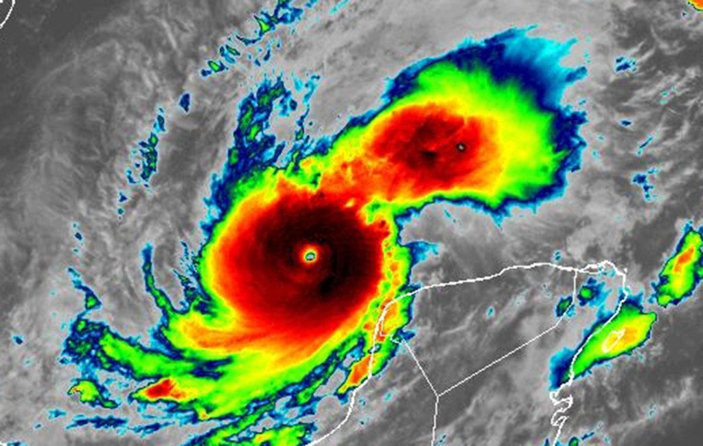
Hurricane Milton strengthened Monday into a Category 5 storm hitting 160 mph sustained winds and forecast to intensify further on its way to an expected landfall on Florida’s Gulf Coast.
The National Hurricane Center in a special 11:55 a.m. update said Milton hit the highest level of hurricane in the Saffir-Simpson Hurricane Wind Scale, and is forecast to top out by Monday night with 165 mph as it skates the warm waters of the Gulf of Mexico just north of Mexico’s Yucatan peninsula, and then dial back some intensity as it shifts northeast toward Florida, but still strike as a major hurricane.
The center of Hurricane Milton was located about 715 miles from Tampa and 125 miles west-northwest of Progresso, Mexico moving east-southeast at 9 mph.
It had rapidly grown from a tropical storm with 50 mph winds Sunday morning to a Category 5 hurricane increasing of 110 mph in intensity in just under 31 hours.
“By tomorrow, its intensity should be dictated by any eyewall replacement cycles, which will likely cause the system to gradually weaken but grow larger,” said NHC senior hurricane specialist Eric Blake.
For now the system has a tight wind field with hurricane-force winds out to 30 miles and tropical-storm-force winds out to 80 miles.
“Milton’s remarkable rapid intensification is continuing. Satellite images show a small eye within the very cold central cloud cover, and the eye is becoming better defined,” Blake said.
He noted only Hurricane Wilma in 2005 and Hurricane Felix in 2007 had more rapid intensification among NHC records.
Its path is expected to shift to the east and then northeast on Tuesday and Wednesday headed up toward Florida’s Gulf Coast within a cone that has also shifted north since earlier Monday.
It now stretches from near Fort Myers Beach north to the Big Bend near Horseshoe Beach, but still potentially targets landfall near Tampa Bay by Wednesday, hitting an area that just endured major surge and damage from Hurricane Helene less than two weeks ago.
Its forecast intensity is expected to be dialed back by landfall, but still at Category 3 strength by 7 p.m. Wednesday just offshore with 125 mph sustained winds and 155 mph gusts.
Storm surge of up to 12 feet is projected by the NHC on parts of coast.
“We’re talking about storm surge values higher than the ceiling,” said Florida Division of Emergency Management Director Kevin Guthrie. “Please. If you’re in the Tampa Bay area, you need to evacuate. If they have called for your evacuation order, I beg you, I implore you, to evacuate. Drowning deaths due to storm surge are 100% preventable if you leave.”
Evacuations on much of Florida’s west coast barrier islands have already begun.
“We had situations where people died of drowning in Hurricane Ian. Had they just gone across the bridge from Estero Bay, Sanibel Island and so on, just across the bridge to the first available shelter that had capacity, they’d still be alive today,” he said.
The Federal Emergency Management Agency announced President Biden had authorized FEMA to coordinate all disaster relief efforts in the state and approved 75% federal funding for emergency protective measures including direct federal assistance to 37 counties that were part of Gov. Ron DeSantis’ original emergency declaration request, and the same level limited to direct federal assistance to an additional 14 counties.
DeSantis said at a briefing Monday morning from Tallahassee that the storm has slowed so might make landfall late Wednesday or early Thursday.
“We don’t know exactly how it’s going to go. I know they say the eye is going to go here or here — that can move. When you’re talking about 30, 40, 50 miles north or south, that will make a huge difference in terms of who gets the worst surge, how much power is ended up taken out, and so we have no way of knowing how that’s going to shake out,” he said. “So the resources are being brought in, and the power restoration effort will begin as soon as it’s safe to do so.”
He said the state was suspending all tolls in the western part of Central Florida as well as Alligator Alley.
“We also have a storm that’s already very powerful now, the forecasts are that it’s going to peak before it reaches landfall, and then weaken. It is still going to be a strong storm,” DeSantis said. “We don’t know that that’s necessarily going to happen, and so this is something that’s going to be really, really significant one way or another.”
The NHC’s intensity forecast said it could reduce strength as it approaches Florida’s coast on Wednesday.
“The system is still likely to be a large and powerful hurricane at landfall in Florida, with life-threatening hazards along portions of the the coastline,” NHC senior hurricane specialist Jack Beven said.
A hurricane watch in Florida has been issued from Chokoloskee to the mouth of the Suwannee River including Tampa Bay, the Dry Tortugas and Lake Okeechobee, while a storm surge watch is in effect for the Gulf Coast from Flamingo north to the Suwannee River, Charlotte Harbor and Tampa Bay.
Inland hurricane watches were issued as of 11 a.m. for all but the eastern counties of the Florida peninsula. That includes Central Florida’s Lake, Marion, Orange, Osceola, Polk, Seminole and Sumter counties, but not Volusia or Brevard, yet.
A tropical storm watch is in effect for the Florida Gulf Coast from Flamingo to south of Chokoloskee and north of the Suwannee River to Indian Pass, and in the lower, middle and upper Florida Keys including Florida Bay.
In Mexico, a hurricane warning is in effect for the coast of the Yucatan peninsula from Celestun to Rio Lagartos, a hurricane watch from Rio Lagartos to Cabo Catoche and from Campeche to south of Celestun, and tropical storm warning from Rio Lagartos to Cancun and from Campeche to south of Celestun.
The NHC began projecting storm surge along the Gulf Coast as high as 12 feet from the Anclote River north of Tampa south to Englewood including Tampa Bay, and as high as 10 feet from the Anclote River north to Yankeetown and from south of Englewood to Bonita Beach including Charlotte Harbor, as high as 7 feet from Bonita Beach south to Chokoloskee and as high as 5 feet from Yankeetown north to the Suwannee River.
“While it is too soon to specify the exact magnitude and location of the greatest impacts, there is an increasing risk of life-threatening storm surge and damaging winds for portions of the west coast of the Florida Peninsula beginning early Wednesday and storm surge and hurricane watches will likely be issued tonight or early Monday,” the NHC stated.
Rainfall also is forecast to dump 5-10 inches across much of the state with some areas getting as much as 15 inches.
While the intensity may fall just before landfall, the wind shear will be push stronger winds farther east.
“Vertical wind shear is forecast to markedly increase as Milton approaches Florida, and some weakening is anticipated,” Blake said. “However, the regional hurricane models are showing the system growing even if it weakens, and we are expecting Milton to be a large hurricane at landfall, with very dangerous impacts spread out over a big area.”
The models still have it as a Category 3 hurricane with 120 mph sustained winds and 150 mph gusts within a three-day cone that for now is targeting landfall near Sarasota but ranges south to beyond Naples and north to near Horseshoe Beach in the Big Bend.
“It should be noted that the average NHC track error at day 3 is around 100 miles, and users should not focus on the exact track,” Blake said.
The system is expected to lose intensity as it crossed the peninsula, but the projected path has it never losing hurricane strength.
The latest forecast path consensus has it moving across southern Central Florida where it would still be a Category 1 storm with 85 mph sustained winds and 90 mph gusts, then exiting over Cape Canaveral in Brevard County into the Atlantic.
“It isn’t like it’s just going to be a rainstorm,” DeSantis said. “I mean, all the way until it exits the state is going to be powerful so please take the appropriate precautions, listen to your local officials, and we’ll get through this. We’ll respond very quickly, but, but this does have the potential to have a lot of damage.”
The debris leftover from Helene poses a major risk, he said
DeSantis had declared a state of emergency for 51 of the state’s 67 counties, up from 34 declared on Saturday.
The updated list includes Alachua, Baker, Bradford, Brevard, Broward, Charlotte, Citrus, Clay, Collier, Columbia, DeSoto, Dixie, Duval, Flagler, Gilchrist, Glades, Hamilton, Hardee, Hendry, Hernando, Highlands, Hillsborough, Indian River, Lafayette, Lake, Lee, Levy, Madison, Manatee, Marion, Martin, Miami-Dade, Monroe, Nassau, Okeechobee, Orange, Osceola, Palm Beach, Pasco, Pinellas, Polk, Putnam, Sarasota, Seminole, St. Johns, St. Lucie Sumter, Suwanee, Taylor, Union, and Volusia counties.
In Central Florida, UCF and Valencia State College canceled classes Tuesday-Thursday while Rollins canceled classes for the whole week. Osceola County announced no classes Wednesday already with other schools likely to announce closures this week later today.
SunRail announced it would shut down beginning Tuesday and remain closed through at least Thursday depending on the storm impact.
“Put your hurricane preparedness plan in place, make sure your gas tanks are filled,” DeSantis said on Sunday. “Make sure you have enough water and nonperishable food to last you as long as the power may be out, clear up loose objects in your yard. Obviously, the big debris piles, you need that to get hauled away. But anything other than that that isn’t debris,” he said.
Impacts on Florida will include storm surge and heavy rains with 5-10 inches and some areas up to 15 inches forecast for portions of the Florida peninsula and Florida Keys through Wednesday night.
“This rainfall brings the risk of flash, urban, and areal flooding, along with minor to isolated moderate river flooding,” the NHC stated.
Much of the state including all of Central Florida remains under a flood watch from Sunday though Thursday, according to the National Weather Service.
“Excessive runoff may result in flooding of rivers, creeks, streams, and other low-lying and flood-prone locations,” the NWS advisory states. “Flooding may occur in poor drainage and urban areas.”
Tampa Bay and the rest of the Gulf Coast of the state just endured major storm surge and wind damage from Hurricane Helene less than two weeks ago.
In addition, swells generated by the system will begin to hit the southwestern Gulf of Mexico coast today, spreading to the north and east by early next week.
The National Weather Service in Melbourne says tropical-storm-force winds could arrive Wednesday morning for Central Florida with the center of the storm hitting the coast late Wednesday afternoon or early Wednesday evening, making its way across the I-4 corridor and emerging off the east coast before daybreak Thursday.
“Deteriorating weather conditions are forecast in the form of heavy rainfall and increasing gusty winds, especially rainbands,” said NWS meteorologist Tim Sedlock. “A few tornadoes will also be in play on Wednesday.”
Rainfall across Central Florida from Sunday through Thursday would range from 4-8 inches with some areas getting up to 10 inches near the I-4 corridor north as well as north-central Brevard County, while 3-6 inches would fall farther south across Osceola and Okeechobee counties and the Treasure Coast.
“The time is now to enact your local hurricane plan and ensure you have supplies, and everything else necessary to ride out this storm,” Sedlock said.
The Space Force’s Space Launch Delta 45 late Saturday put Cape Canaveral Space Force Station and Patrick Space Force Base under HURCON 4 predicting surface winds in excess of 58 mph within 72 hours.
The NHC also is keeping track of two hurricanes in the Atlantic.
Hurricane Kirk cone of uncertainty as of 11 a.m. Monday, Oct. 7, 2024. (NHC) As of 11 a.m. Monday, what had been Hurricane Kirk became Post-Tropical Cyclone Kiri, and was located about 6555 miles west-northwest of the Azores moving northeast at 29 mph with sustained winds of 75 mph.
“An even faster east-northeastward motion is expected during the next couple of days,” forecasters said. “Although gradual weakening is expected, Kirk is forecast to remain a large and strong extratropical low during the next couple of days.”
It had earlier this week reached Category 4 level becoming the season’s third major hurricane ahead of Milton.
Hurricane-force winds extend out up to 90 miles and tropical-storm-force winds extend out up to 310 miles from its center with it approaching Europe by Wednesday.
Despite its distance across the Atlantic, swells from Kirk continue to hit the east coast of Florida and elsewhere this weekend bringing life-threatening surf and rip current conditions.
Hurricane Leslie cone of uncertainty as of 11 a.m. Monday, Oct. 7, 2024. (NHC) As of 11 a.m. Monday, Hurricane Leslie was located about 1,120 miles west of the southernmost Cape Verde Islands moving northwest at 13 mph with maximum sustained winds of 85 mph, which makes it a Category 1 hurricane.
This general motion is expected to continue over the next few days followed by a turn toward the north-northwest on Friday,” forecasters said. “Gradual weakening is forecast through the week, and Leslie is expected to weaken to a tropical storm in a day or so.”
Hurricane-force winds extend out up to 15 miles and tropical-storm-force winds extend out up to 105 miles from its center.
The tropical outlook as of 11 a.m. Monday, Oct. 7, 2024. (NHC) The NHC also has its eyes on a tropical wave expected to move off the west coast of Africa in the next few days.
“Thereafter, environmental conditions appear only marginally favorable for some development of this system while it moves westward or west-northwestward across the eastern tropical Atlantic,” forecasters said. “The system is expected to move near or over the Cape VerdeIslands on Wednesday and Thursday, and interests there should monitor its progress.”
The NHC gives it a 30% chance to develop in the next seven days.
The 2024 Atlantic hurricane season has had 13 named storms including nine hurricanes, four of which grew to major hurricane strength, and four tropical storms.
Hurricane season runs from June 1-Nov. 30.
Originally Published: October 7, 2024 at 10:34 a.m.