Sunday and Monday are 9 First Warning Weather Alert Days due to a major snow storm moving into the Tri-State.
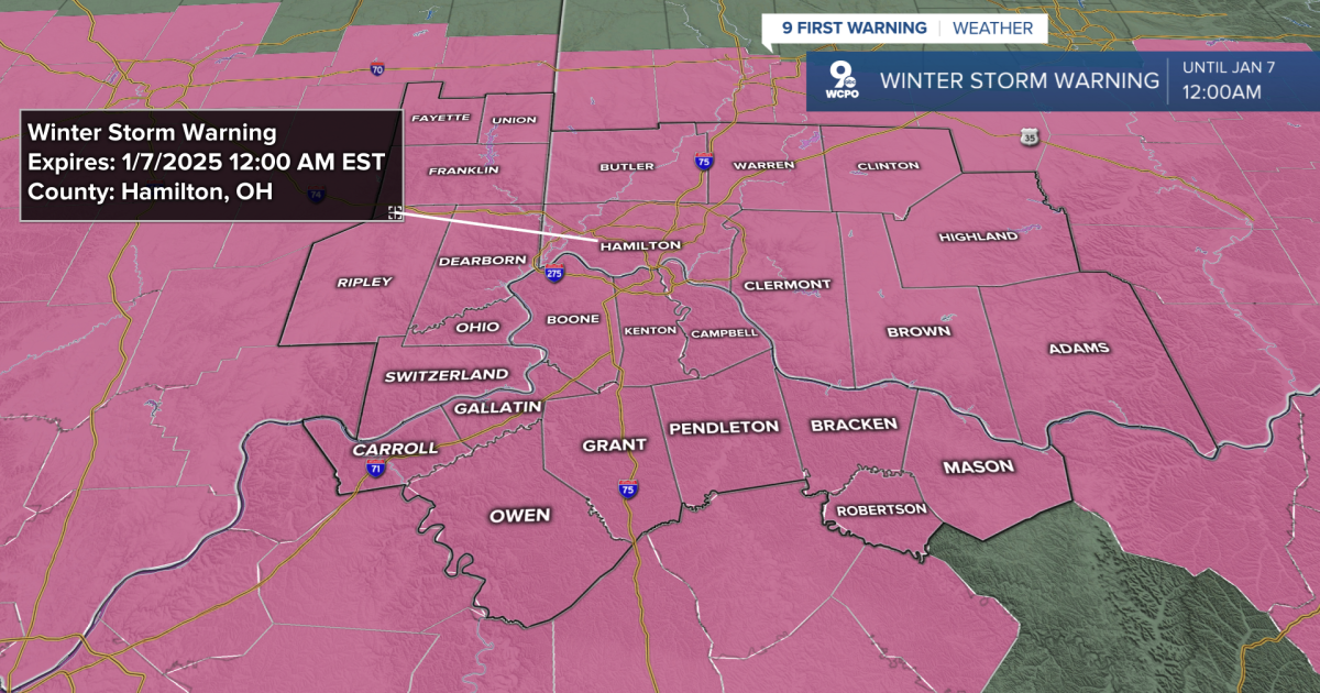
A WINTER STORM WARNING is out for the entire Tri-State starting at 10 a.m. Sunday morning and will remain in effect until 12 a.m. (Midnight) Tuesday.
9 FIRST WARNING: A Winter Storm Warning is out for the ENTIRE Tri-State starting at 10 a.m. Sunday & will be in effect until 12 a.m. Tuesday. Snow totals of 8-12″ are likely with some areas seeing locally heavier amounts. Travel will be VERY difficult#wcpo #cincywx pic.twitter.com/gY77byLbxU
— Brandon Spinner WCPO (@wxSpinner89) January 4, 2025
TIMELINE:
This storm will likely have three “parts” or periods to it, all of which are important. Part one is heavy snow, part two is ice accumulation, and then the final part is another round of light to moderate snowfall. Here is how we expect this to develop.
Sunday Morning will be the start to the system, but it will be the least impactful of the event. Some light snow could start as early as 10 a.m. for areas to the west of Cincinnati. The atmosphere should be quite dry, so anything we see will be light, as we begin to moisten the levels of the atmosphere.

As we move past noon and into Sunday Afternoon this is when the snow will really start to pick up, especially after 1 p.m. for most areas. Moderate to heavy snow will move in, which is when roads will start to become covered. Temperatures will be into the mid to upper 20s, and winds from the southeast at 5 to 10 mph could lead to some visibility issues along with the snowfall.

The main impact of Sunday will be Sunday evening. This is when we expect to see our heaviest snow, especially between the hours of 7 p.m. to 10 p.m. During this time period, we will very well see snowfall rates of 1 to 2 inches per hour. This, along with freezing rain starting to develop in Northern Kentucky, is when travel will likely become impossible. Snowfall rates of that measure, especially after earlier snowfall, start to cripple travel.

Part two, which I mentioned earlier, begins around midnight Monday, or slightly after. While temperatures at the surface will remain below freezing in the mid to upper 20s, a warm pocket around a mile up in our atmosphere will change the snow to freezing rain. This is where the biggest ice accumulation is expected. The biggest impact from this will be for areas along and south of the Ohio River, into Northern Kentucky. Where we don’t see this occur it should continue to stay as snow, especially as you get further north of the Ohio River.

By daybreak of Monday Morning there will still be areas of freezing rain, but we will likely be in the time period of our lightest precipitation. Drier air will start to impinge the system, creating what we call the “Dry slot.” While you may get lulled into sleep thinking that this is the end of the event, we still will have another wave roll in later in the morning and Monday afternoon. This time period will produce some light freezing rain or light snow showers. Accumulation during this time period should be minimal, but still hazardous. That is because wind speeds of 15 to 30 mph will add blowing and drifting snow, limiting visibility and making travel VERY difficult.

After a brief break in the activity Monday morning, wrap-around moisture will push in during the late morning and Monday afternoon, which is when part three of this system starts. This brings in colder air, along with light to moderate snow. Wind speeds will also stay strong. Additional snow from this should be between 1 to 3 inches for most areas as this finally wraps up later in the afternoon and evening Monday.

So time for what you have all been waiting for… How much snow will we get?
The amount of snow that most of the Tri-State will see is likely to be between 8 to 12 inches. These amounts will greatly depend on how much of that snow changes over to freezing rain late Sunday into early Monday. The more freezing rain we see, the lower the totals. Totals are more likely to be lower the further south you get in Northern Kentucky. While we think most of the area will see 8 to 12 inches of snow, there is a very strong chance that local areas see heavier snowfall. Personally, I wouldn’t be surprised if select locations see near 15 inches by Monday afternoon.

ADDITIONALLY, we will see some ice accumulation. This is much more crippling, especially once we start to see 0.25″ of ice or more. That is much more likely for areas of Northern Kentucky and towards Lexington. However, areas along the Ohio River could still see close to a tenth (0.10″) of an inch of ice, which still creates big travel issues.

Once it is all said and done the story becomes the COLD! Temperatures on Wednesday and Thursday mornings will be into the single digits, so this snow will be around for a while.
SATURDAY NIGHT
Clouds building
Dry & calm
Low: 20
SUNDAY
Winter Storm Warning
Heavy snow to start, then freezing rain late
High: 28
SUNDAY NIGHT
Heavy snow,
Freezing rain/ice at times
Low: 23
9 First Warning Weather 24/7 Livestream
==========

